
Pack your fishing pole! A four day weekend cycle tour along the Sierra Vistas Scenic Byway blew me away with sweeping Sierra views, pristine trout streams, and just the right amount of dirt biking adventure.
Sierra Vistas is a ~100 mile loop in the piney Sierra foothills just south of Yosemite National park. An adventurous, transit based trip will take you four days. Alternatively, park the carpool at Bass Lake and complete the loop in 3 days. Both itineraries leave you plenty of time for swimming, fishing and roasting marshmallows.
The three day loop was put together by Lis at the Norcal Cycle Touring Meetup group! Check out her extensive maps and logistics here.
Trip at a glance
Maps: My Delorme California Atlas served well-enough for sketching out a general route, but you’ll want more detailed maps for those cross-country “shortcuts.” Consult the Sierra National Forest Visitor Map (basic route and scan here), and the National Geographic 810 Shaver Lake / Sierra National Forest Trail Map.
Season: Check the snow levels for early season jaunts. On Labor Day, temperatures were in the 90s during the day, but it felt cooler with the mountain breeze and easy water availability. A 40 degree bag with warm layers and a bivy or a tent served us cycle tourists well. Those with warmer bags slept on the dirt or on picnic tables.
Fishing: I saw guys bring in trout with either power bait, or lures on light tackle. Don’t forget your fishing license and sense of humor, if you’re a novice pescadore like me!
The Route:
Transit options: From the Bay Area, the early San Joaquin Amtrack train will get you to the Madera at 11am. The San Joaquin line does not require bikes to be boxed. On the return trip, the Yosemite Area Regional Transportation System (YARTS) provides connections between the Merced Amtrak stop and stops along Highway 140, including Mariposa and the Yosemite Bugs Hostel (schedule here).
Day One: Madera Amtrak to Bass Lake
Four-day adventure bikers will take Amtrak to Madera, a hot and dusty town just north of Fresno. Grab a burrito; you’ll need it for the next 50 miles and the 3500 ft or so of climbing to Bass Lake. Carpoolers set off evening-like straight for Bass Lake, cutting out the climb from the Central Valley. Wishon Campground at Bass Lake was very busy on Labor Day, so reserve ahead.
From Madera, you have two options.
- take the mostly paved route here (the only unpaved section is hard packed gravel due to repaving along the first part of Rd 200 to North Fork).
- The adventurous, partially unpaved route here features a short section of washboard gravel at the beginning of Rd 406. This road ends in a rutted and rocky backroad and connects onto the busy Hwy 41. The rest of the climb is straight forward.

Day Two: Bass Lake to Rock Creek Campground (~30 miles paved, route here)
If you carpooled out to Bass Lake, you can leave the vehicle in the overflow parking for the Wishon Point Campground for a fee. Your last chance for groceries for the next two days are in North Fork. From here on, navigation is easy — just follow the scenic byway. Water is available at Rock Creek Campground. A nice trout spot and swimming hole is located at a pullout just a 1/2 mile uphill of the Rock Creek campground.
Day Three: Rock Creek to Clover Meadow Station (~30 miles paved, route here)
After Rock Creek, the scenic byway heads serves up expansive views of the Mammoth Mountains and Yosemite area backcountry. It must take too much gas to drive out here, because vehicle traffic drops off dramatically. Other than cycle tourists, you’ll find hunters, forest rangers, and the occasional horse packing outfit out.
Clover Meadow Station is located two miles downhill from the scenic byway, accessed by a gravel road. Camp at Clover Meadow for the water spigots and facilities, and early evening visits by mama cows and their calves. After making camp, continue on one mile by foot or bike to Granite Creek, where you’ll find granite pools and trout holes. A fisherman gave me a sub-pound beauty of fish out of there, and I wish you the same luck.
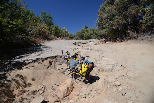
Day Four: Clover Meadow to Yosemite Bugs Hostel (~70 miles, mixed paved and dirt with mostly well-maintained gravel roads; route here)
The final leg of the trip features an exhilirating descent on dirt, past glacier sculpted granite domes and other curiosities. Jone’s Store at Beasore Meadows serves up tri-tip sandwiches and homemade pies at lunch time.
If you’re taking the three day route, continue on pavement back to the car at Bass Lake. Otherwise, turn off onto Forest Road 6S10X for more gravel. The fast and winding descent continues to Hwy 41. The “shortcut” between Hwy 41 and 49 features a bike + hike on a steep, unmaintained, not well-signed fire road. Keep your bearings and carry on. The last segment of the day along Triangle Rd is a gorgeous rolling ride through working ranches and well-paved backroads.
To end the trip, take the YARTs bus back from any one of the stations along Hwy 140. If you have an extra evening, take a shower and stay an extra night out at the Yosemite Bugs Hostel. The earliest YARTs bus to Merced Amtrak leaves just after 6am.

2 thoughts on “Bike-fishing the Sierra Vistas Scenic Byway”